Posted by: sirken2007 | April 11, 2008

Wednesday Storm Damage Report

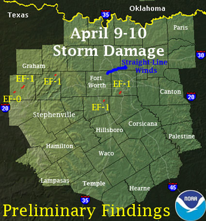
Following is the Storm Damage Report from NOAA for the storms that blasted through Wednesday and Wednesday night. As you can see, there were 5 confirmed tornadoes, in all.

As illustrated in the report below, Wednesday and Wednesday night were extremely intense and I know it kept quite a few spotter networks rather busy! I happened to be lying in bed, awake, when the storms blew through Wednesday night and following is a short report of what I observed while lying in bed listening to the weather rage outside. I noticed that it was dead quiet outside, for starters, then I heard the first rumble of thunder, and it sounded as though it were a little way off, yet. However, after hearing that first rumble of thunder, not a couple of minutes later, literally, the wind started blasting the house, followed almost immediately by extremely heavy rainfall. When I say blasting winds, I mean they were fierce; in line with the reports of 75+ MPH. It was enough that I stayed awake just in case. Plus, it didn’t help that I thought I heard the tornado siren sounding down the street. I still have no idea if the siren did sound or not. Anyway, almost as soon as it began, it was over. I’d say it lasted maybe 15 minutes. One thing is for sure, it was definitely a heck of a day for me; one that I won’t likely forget anytime soon!

April 9-10 Severe Weather Outbreak Across North and Central Texas

Widespread wind damage resulted from an intense line of thunderstorms that developed Into a bow echo as it approached the Metroplex. The term bow echo Describes the radar presentation of the storms…which accelerates or bows out as a result of the strong winds. While most of the damage surveyed suggested straight-line winds of 70 to 75 mph…at least two tornadoes occurred with an intense circulation across northeast Johnson County and southern Dallas County.

The Johnson county tornado touched down north of Alvarado near Happy Hill at approximately 330 am cdt and traveled northeast for approximately 3 miles to Pleasant Point. Several homes sustained significant roof damage…and at least three homes were considered total losses. Many sheds…detached garages…and other small outbuildings were damaged or destroyed. Several trees were uprooted…and at least two fell onto homes. Power lines were downed throughout the area. This tornado is rated ef-1 with estimated wind speeds of 90 to 95 mph. The path width is estimated to be approximately 50 yards wide.

The second tornado touched down in Desoto at approximately 4 am in the central portion of the city along Meadowbrook road just west of Hampton road and traveled east-northeast to near the eastern limits of the city just north of wintergreen road. Again…several homes had substantial roof damage…with one home near the beginning of the track losing the majority of the roof. Many downed trees were observed along with damage to sheds and outbuildings. Power poles and power lines were also downed. This tornado is also rated EF-1 with estimated wind speeds of 95 mph and a path width of 40 yards. more isolated damage was reported southwest of the tornado across southwest sections of Desoto…but this damage was more scattered in nature and appears to be the result of straight-line winds.

The survey team also surveyed damage in the mid cities area and into Southwest collin county in plano. While much of the observed damage is consistent with high-end straight line winds of 75 to 80 mph…additional information is being gathered from these areas from emergency management officials and eyewitness accounts…and this assessment should be considered preliminary.

This damaging line of thunderstorms was part of one of the most active 24-hour periods in recent North Texas weather history.

Stephens County

Based on ground and aerial surveys of the damage area…it appears two tornadoes occurred in Stephens County. The first tornado developed along Farm Road 576 east of the Eolian community. Trees and a shed were damaged west of the intersection of F.M. 576 and F.M. 3418. A large metal building was damaged along F.M. 3418 and several large storage containers were blown across the road. This tornado will be rated as an EF-0 with winds of around 80-85 mph. Path length was 2.3 miles and average path width around 75 yards.

The second damage swath started approximately 1/2 mile west of U.S. 183 and south of F.M. 2231. Power pole damage was noted along F.M. 2231 and U.S. 183. Roof and barn damage occurred along U.S. 183 as well.

The most significant damage occurred at and just west of the Stephens county airport. Several homes had considerable damage along county road 150. Several of the airport buildings had overhead doors blown in…roof damage…and damage to some of the girders.

Northeast of the airport…additional damage to power poles was noted near the eastern end of f.m. 2231. The damage swath continued across U.S. 180 between Highways 67 and 207. Damage to mobile homes…roofs…power poles…and storage buildings occurred in this area. This tornado will be rated as an upper-end EF-1 with winds near 110 mph. Path length was 7.1 miles…and the average path width was around 400 yards.

Palo Pinto County

Based on a survey of the damage near the Oran community in northeast Palo Pinto county…it was determined that a tornado affected this area. The damage swath began just west of Oran. Several trees were uprooted or had large limbs snapped. A few homes in Oran had portions of roofs removed. East of Oran on F.M. 52…power poles were snapped. This tornado will be rated an ef-1 with winds of 85-90 mph. Path length was 1.6 miles and average path width was 100 yards.
Posted by: sirken2007 | April 10, 2008

No Damage in Arlington or Grand Prairie

I just drove my usual route through Arlington and Grand Prairie and saw no apparent damage from last night’s powerful line of storms that moved through. The most that I saw were a ton of leaves and very small branches down in yards and, in a few cases, littering a few neighborhood streets. I did come across two sets of stoplights that were completely out, but other than that, I’d say Arlington and Grand Prairie were very lucky.

Posted by: sirken2007 | April 10, 2008

04-09-2008 Tornadic Supercell

Yesterday’s chase was interesting, to say the least. My chase partners for the day were my buddy Ryan and his friend Chris. This was Chris’s first chase. We left Denton around 1030 CST and headed west on US-380 to Haskell, TX, about a 3-hour drive. This part of the day was extremely uneventful as we remained under a thick cloud cover and fog, with rather cool air temperatures (~mid-upper 50’s F) the entire drive to Haskell. Once in Haskell, we hopped off 380 and onto 277 south toward our first data stop in Stamford, TX. This data stop was a good one, as we were able to see the nice cloud clearing just south of Abilene, as well as note the intense heating taking place with the warm front (San Angelo was already at almost 85 F at 18z).

We left the rest area and headed down to Abilene to make a pit stop for lunch. After about 15 minutes on the road to Abilene we finally got into the clearing we had seen on satellite and immediately noticed some advanced convection taking place to the south. There were some very tall, rock hard towers already in place. Needless to say, we got very excited, as we had anticipated this after seeing the clearing, position of the warm front, and the reported temps in San Angelo.

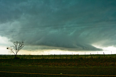
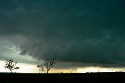
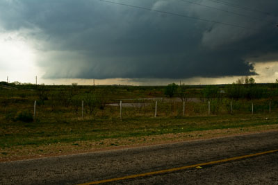
We stopped in Abilene, just south of I-20 at Taco Bell for lunch. As soon as we finished eating Ryan informed us of a Tornado Warning coming across NOAA Weather Radio for Abilene for a storm that we just happened to be watching during lunch out the window of the restaurant. We ran to the car, literally, and bolted north and then west to intercept. Almost immediately we saw the mesocyclone with a rather large wall cloud. We knew instantly this was the storm we’d been hoping for. We got to a clear spot, stopped and jumped out to take pictures quickly. The only pictures of the day are seen below, in sequence, from a couple of different positions that were maybe a mile apart. Some interesting notes about storm activity at the time of these pictures: there was very well defined wall cloud rotation, and, on the right side of the picture the storm was pulling in a TON of material at a rapid speed. This motion was actually the forming inflow tail and I cannot emphasize how fast scud was being pulled into this storm at the time. Simply amazing! These pictures were all taken just barely north and west of Abilene as the storm moved over Abilene.

Lightning activity became dangerous enough to move us back inside the car and onto the road to change positions. To our knowledge, this storm never produced a tornado, and we decided to leave it for better activity further east with a newly Tornado Warned storm. We tried to make a data stop at a rest area on I-20 just east of Abilene to get radar updates and confirm what we were seeing in the sky. As we waited for the rest area wireless connection to connect to my MacBook Pro, we could see intense rotation in the storm just a mile or two north of our location. We watched the storm develop and organize for a few minutes while still awaiting a wireless connection. We really wanted to get on the road and head north to track it, but the wireless at the rest stop would not cooperate. A friendly trucker offered the use of his Dell laptop connected to a Verizon wireless network, but it was too slow. In the end, we gave up on getting data and headed east on 20 to 283, where we dumped 20 and headed north. About 25 miles west of Breckenridge we could see the back side of the storm but we were too late to catch the large, violent tornado that was carving a path through the south side of Breckenridge. We were also getting reports over NOAA Radio of another tornado taking shape just east of Breckenridge, though I never did hear if the tornado was actually ever confirmed. One interesting thing to note about the storm at this time is that it had morphed into a massive HP beast, so, if we had caught up in time for the twister, it could have been a very dangerous situation as I am convinced that it would have been completely rain-wrapped as it plowed through town.

We got to Breckenridge just minutes after the twister hit, but had to backtrack because of closed roads due to extensive damage east of the city. Thankfully no one was seriously injured! The rest of the day consisted of a vigorous chase through rural areas all the way back to Denton. We drove back to catch 183 north in the middle of town and followed it to Farm Road 578, which we followed north to 209, which took us east to 380 East. We finally caught up with the storm in Bridgeport, just north and west of the Metroplex, but it had remained as a raging HP beast and we got pounded with torrential rainfall. Once we got to Runaway Bay, just west of Bridgeport, we began to notice moderate Flash Flooding, and it only got worse as we moved east of Bridgeport, were we began to see entire parking lots that were flooded. Best estimate of rainfall rate is 6+ inches/hour. Also, this storm maintained constant low-level rotation all the way from Abilene to at least Denison, TX, which is on the Red River, 75 miles due north of Dallas! We are talking about 5+ hours of rotating wall clouds and, from what I hear, one other tornado besides the Breckenridge twister. Amazing! We drove into Decatur, in blinding rain, but noticed that we were not quite out of the game, as we were in the vicinity of the rotating wall cloud. We stuck with it a bit into Denton County, but never could get a visual on the wall cloud and ultimately decided to give it up and call it a day.

Overall a very exciting chase day, but largely uneventful due to the bad decision to wait too long for data. Unfortunately, due to money constraints this is most likely my last chase for the season.

Posted by: sirken2007 | April 9, 2008

Chase Day, 04-09-2008

Final Update, 03z(2213 CST): Back home after a vigorous chase east through W Central Texas, after wasting time on a lost data connection at a rest stop east of Abilene. Will post full chase account tomorrow morning. Good night!

Update, 19z (1400 CST): Currently just north of Abilene, getting ready to make our way south to San Angelo. Massive clear slot in the warm sector there and tornadic supercells are expected to develop a little later. More updates as time allows.

I am currently neck-deep in preparations for today’s chase just west of the Metroplex. I am currently targeting Haskell, TX as the first stop of the day, though I don’t expect to stay there long since it appears as though the action will be to the north and east of Haskell. I am merely planning on stopping in Haskell for a quick lunch and data update and then anticipate heading northeast toward Seymour, TX. Again, as I get on the road, check data, and monitor weather radio, the whole plan could change drastically. I will add an update to this post once I stop for data in Haskell, sometime around noon or 18z (1300 CST). I hope to have my chase partner, Ryan Goff, with me today, as well. Wish me luck!

Also, one other note before I leave. I would love to hear any thoughts or comments regarding my post late last night about the 1979 Red River Tornado Outbreak. That event is something that has greatly impacted my life and driven me in my passion for the weather, and any other opinions or views out there would be greatly appreciated!

Posted by: sirken2007 | April 8, 2008

April 10, 1979 Red River Valley Tornado Outbreak

All pictures and graphics courtesy the NWS Office in Norman, Oklahoma.

Above you can see the overview map of the Red River Valley Tornado Outbreak of April 10, 1979. This outbreak is significant to me mainly because I was not quite 1 year old when one of the tornadoes struck Wichita Falls, TX that afternoon. My mother has told me many times about how terrible and frightening this storm was when it came barreling into the city of Wichita Falls. She recounts that it appeared as though the sky had descended to the ground and was scraping through the city. Indeed, the tornado was quite wide and did F4 damage throughout most of the city of Wichita Falls. This outbreak is significant to me, also, because it is the single event in my life that has ignited my passion for meteorology and driven me to become a storm chaser.

Overall, there were about 30 tornadoes, total that touched down and wreaked havoc throughout the upper Red River Valley that day. Below I have linked pages to the NWS site dedicated to the study of this outbreak. I encourage everyone who may be interested to read them, as I feel a lot can be learned from the study, even today. Plus, I will only highlight just a few things about the actual Wichita Falls storm and paste a few pictures. A much deeper and more thorough insight can be had be reading the entire study found here: http://www.srh.noaa.gov/oun/wxevents/19790410/

Here is an excerpt from the synopsis/discussion page of the site, talking about the Wichita Falls supercell:

The Wichita Falls storm produced its first tornado at 1653 CST (4:53 PM) near Seymour, TX. The storm’s second tornado, the terrible Wichita Falls tornado, formed at 1755 CST (5:55 PM) to the southwest of the city and moved through the southern and eastern sides of Wichita Falls shortly after 1800 CST (6:00 PM). The tornado finally ended near Waurika, OK after traveling 47 miles. The Wichita Falls storm produced a third and final tornado about 2000 CST (8:00 PM) near Pruitt, OK

The synopsis/discussion page can be found here: http://www.srh.noaa.gov/oun/wxevents/19790410/burgess.php

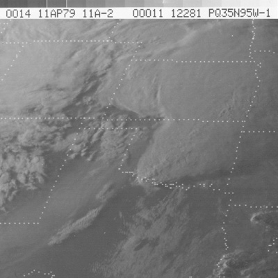
Below is a satellite image of the Wichita Falls storm. This image was taken at 0z, which was 6 PM CST.

Here is another, more extensive excerpt from the synopsis/discussion page:

The Wichita Falls storm formed north of Abilene, TX. It generally moved to the northeast, but turned to the right along the middle of its path, the period during which it produced its violent tornado. During its life, radar-derived storm tops exceeded 50,000 feet and reflectivities were higher than 50 dBZ. It is interesting to note that the Seymour and Wichita Falls tornadoes both formed during periods of relative decline in storm-top height and reflectivity values, a characteristic that has been noted for a number of supercell storms that have produced several cycles of tornadoes. In particular, note the sharp decline in reflectivity near the genesis time and during the life of the Wichita Falls tornado with maximum values less than 45 dBZ for a brief period. During this period, large hail was occurring in the central and northern portions of Wichita Falls as the tornado devastated the southern portion of the city. No explanation for the unusually low reflectivity values with that phase of the storm (sensed by several radars) has been developed.

The Norman Doppler radar was used to collect dense data (0.5o azimuth spacing and 150 meter gate spacing) on the Wichita Falls storm during the interval leading to the formation of the violent tornado. At 1730 CST (5:30 PM), a core of greater than 50 dBZ and two mesocyclones were seen with the storm. The northeastern mesocyclone in the mesocyclone pair was the occluding parent circulation of the Seymour tornado while the southwestern mesocyclone in the pair was the developing parent circulation of the Wichita Falls tornado. By 1800 CST (6:00 PM), the storm had taken on a very classic supercell look with the tornado-associated mesocyclone and hook echo in the right rear portion of the echo. Note that the 50 dBZ core was no longer evident.


Above is a view looking southwest near Memorial Stadium in Wichita Falls, Texas at the time of tornado touchdown. McNiel Junior High School is shown in the middle left of this photo. The school building was totally destroyed by the tornado.

Above is a view looking north from the south shore of Lake Wichita at the tornado approaching Wichita Falls, Texas. The tornado has widened and intensified at this stage.

The following excerpt is from the Wichita Falls tornado photographs page:

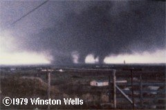
After the tornado left Wichita Falls and travelled northeast, it entered Clay County and changed its appearance. The tornado became multi-vortex, displaying as many as five satellite vortices rotating around the center of circulation. In this stage, the tornado did extensive damage just south of Dean and near Byars, destroying a large number of rural homes, but causing no more fatalities.

Below is a picture showing the tornado and several satellite vortices. I will note here that this aspect of this tornado is what has continued to interest me the most about the outbreak. In my personal, directed studies over the past few years, I have noticed that most, if not all, strong and violent tornadoes are accompanied by satellite vortices. This is something that I feel bears further investigation.

I will end this post with the following, final excerpt from the synopsis/discussion page. It goes without saying that the April 10, 1979 Red River Tornado Outbreak is a significant event and one that has provided multitudes of great information about severe storms and tornadoes.

Lessons to be Learned from the Wichita Falls Tornado

1. Tornado warning and preparedness systems are worth the time and effort it takes to maintain them. All who have looked at and studied the event agree that the death toll would have been much larger had there not been not been such systems in place and functioning on April 10.

2. Vehicles (cars, pickups, and trucks) are poor protection and should be avoided during tornado situations in larger cities where travel is congested and tornado escape routes are not readily available and open for use. The majority of the fatalities were in vehicles, and a number of those victims left homes that were undamaged by the tornado only to be caught in its deadly path as they tried to flee.

3. Well-built modern houses, in general, offer fairly good protection from tornadoes. Some or all of the walls remained for well-built homes (photos 4-6 on the Wichita Falls damage page) and bathrooms in particular provided good protection. Although roughly 4,000 homes were struck by the tornado, there were only five fatalities of people inside homes along the path of the tornado. Many of the 1,800 injured, however, were in homes. This means that those people who moved to the center part of their houses, got down low, and covered themselves, by-in-large escaped with their lives, sustaining injuries instead of death.

4. Even though lesson #3 (above) is true in a violent tornado, the only complete guarantee of safety comes from an underground shelter, an above-ground shelter, or an extremely strongly-built building. McNiel Junior High, a new concrete/steel-reinforced building was not built well enough to provide safe shelter from the tornado. The Southwest National Bank Building was totally destroyed except for its concrete vault, a proxy for an above-ground shelter.

5. As bad as the tornado was, it could have been worse. If McNiel Junior High had been fully occupied by students and teachers at the time of the tornado, there would have been hundreds of additional casualties and many more deaths. Very large groups of people gathered in tornado-vulnerable places, such as schools, stadiums (such as Memorial Stadium), and outdoor events, are disasters waiting to happen. Every year in the United States the threat of a catastrophe looms whenever tornadoes approach large gatherings of people. Fortunately, on April 10, 1979, McNiel Junior High was almost totally unoccupied when the tornado struck and a worse catastrophe was avoided.

Thank you to the NWS Norman, OK Office for their thorough investigation and study of this amazing tornado outbreak, and thank you to all my readers out there who have taken the time to read about this event that has greatly impacted my life in more ways than one.

Older Posts »

Categories